

The UN General Assembly has approved a resolution promoting the use of the Equal Earth projection map to more accurately represent Africa's true geographic size, overcoming distortions of traditional maps.
On September 4, 2026, the United Nations General Assembly overwhelmingly endorsed a resolution advocating the use of a new world map projection that depicts Africa’s size more accurately. The resolution, sponsored by Togo and supported by the African Union, was passed with 164 member states voting in favor, with the United States opposing and six others abstaining.
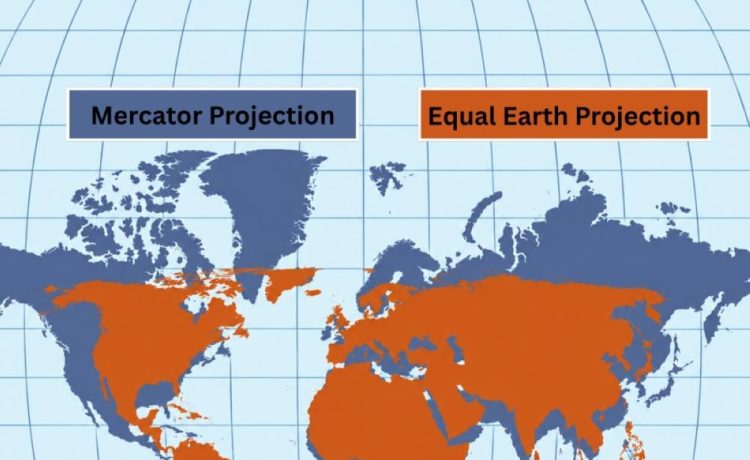
The resolution encourages governments and institutions worldwide to adopt the Equal Earth projection rather than the traditional Mercator projection, which has been prevalent since the 16th century. The Mercator map, initially designed for European navigation, significantly exaggerates the size of regions near the poles—such as Greenland and North America—while minimizing the scale of continents like Africa and South America.
In contrast, the Equal Earth projection, developed in 2018, follows the Earth’s curvature and shows landmasses in their true proportions. For example, Africa is approximately 14 times larger than Greenland on the Equal Earth map, a fact obscured by the Mercator projection where their sizes appear comparable.
Togo’s Foreign Minister Robert Dussey highlighted the importance of maps in shaping global knowledge and perceptions: “Maps guide education, nourish the imagination, and influence collective perceptions.” Campaign efforts from African advocacy groups, including Africa No Filter, called for accurate representation in educational materials, media, and digital platforms. The French Foreign Minister Jean-Noël Barrot echoed this sentiment, stating that correcting distorted representations is an “act of truth.”
While the resolution does not mandate the replacement of the Mercator map, it urges international adoption of the Equal Earth projection for a more truthful representation of the world’s geography. Geographers emphasize that outside of specific navigation needs, the Equal Earth projection provides a more reliable visualization of global spatial realities.
This development is significant in correcting historical cartographic biases and promoting a more equitable view of the African continent, which has long been undervalued in traditional world maps.
Sources referenced:
- https://thehimalayantimes.com/world/un-general-assembly-endorses-a-new-world-map-that-shows-more-accurately-africas-size