

The issue in itself goes back to the early 19th century, when the British ruled India and Nepal was a conglomeration of small kingdoms under the reign of King Prithvi Narayan Shah.
written by Παύλος Ελένης
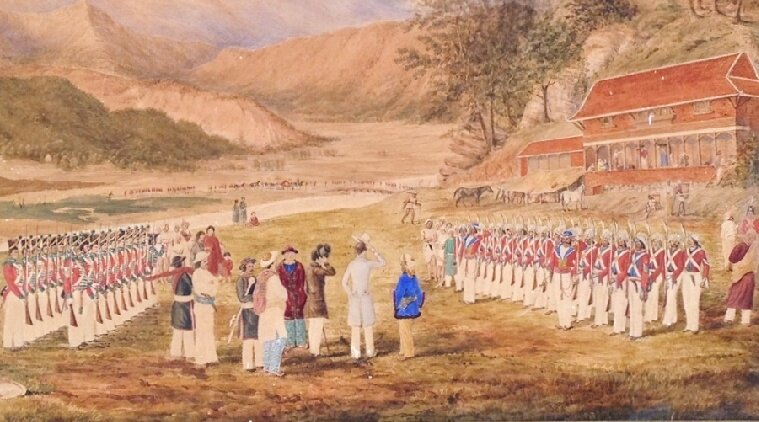
The Anglo-nepalese war came to an end with the signing of the Sugauli treaty. The treaty delimited the boundaries of Nepal, as it stands today. (Source: Wikimedia Commons)
As Nepal unveiled a new map of its territories this week, the country’s land management minister Padma Aryal called it ‘historically pleasant’ occasion. However, the move drew sharp criticism from India which said the map includes parts of Indian territory. “This unilateral act is not based on historical facts and evidence,” said the Ministry of External Affairs (MEA).
Also read: India rejects Nepal’s new map: ‘Artificial enlargement of territorial claims unacceptable’
This battle over the historical accuracy of a geographical territory is one that has been brewing between the two neighbouring countries for the past several decades now. The bone of contention is the Kalapani-Limpiadhura-Lipulekh trijunction between Nepal-India and China (Tibet). Located on the banks of the river Kali at an altitude of 3600m, the Kalapani territory lies at the eastern border of Uttarakhand in India and Nepal’s Sudurpashchim Pradesh in the West.
India claims the area is part of Uttarakhand’s Pithoragarh district, while Nepal believes it to be part of its Dharchula district. Matters came to a boil earlier this year, when India opened an 80-km road linking Uttarakhand with Lipulekh, across the disputed piece of land.
Also read: Explained: The new Indian road to Lipu Lekh, Nepal’s protests, and the area’s strategic importance
While the territory is of strategic importance to India and Nepal, the issue is complicated by the contest over the historicity of cartographic evidence that both sides claim to be most accurate. The issue in itself goes back to the early 19th century, when the British ruled India and Nepal was a conglomeration of small kingdoms under the reign of King Prithvi Narayan Shah.
The British-Nepalese relations
Historian John Whelpton in his exhaustive work, ‘The history of Nepal’, writes: “The single image most strongly associated with the history of modern Nepal is surely that of Prithvi Narayan Shah of Gorkha, girded for battle, a look of determination in his eyes and his right hand pointed skywards.” Shah is believed to be the most ambitious ruler among the Gorkhas, under whose rule in the late 18th century, Nepal was unified, its domains stretching out as far as Sikkim in the East and the Garhwal and Kumaon region of Uttarakhand in the West.
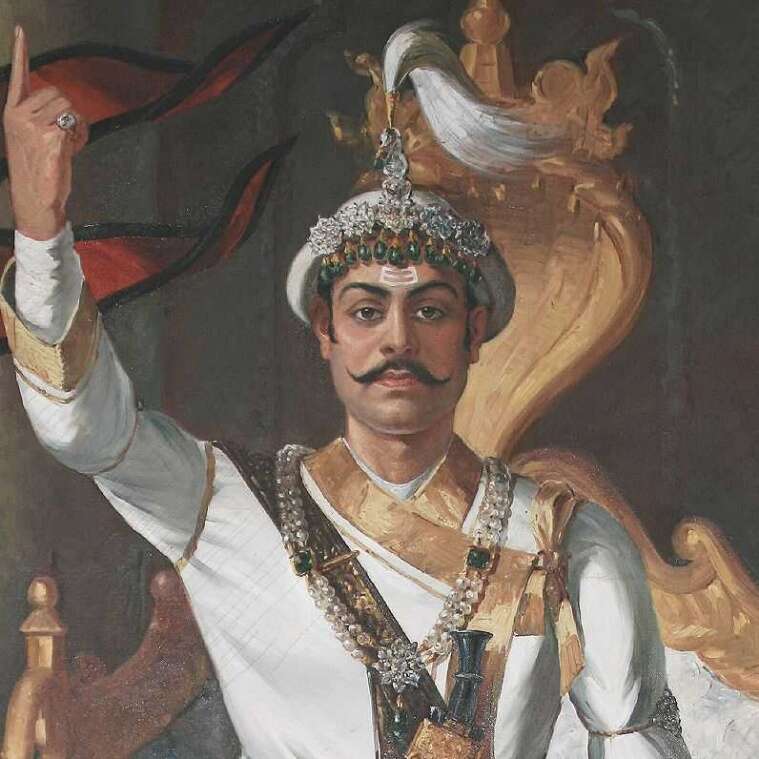 Prithvi Narayan Shah is believed to be the most ambitious ruler among the Gorkhas, under whose rule in the late 18th century, Nepal was unified, its domains stretching out as far as Sikkim in the East and the Garhwal and Kumaon region of Uttarakhand in the West. (Source: Wikimedia Commons)
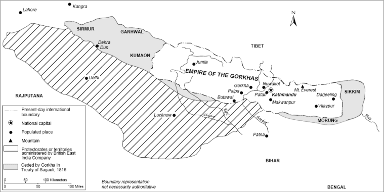
By the second decade of the 18th century, the English East India Company (EIC) too had acquired a formidable presence in the subcontinent, and had strengthened its main bases in Madras, Calcutta and Bombay. By the early 19th century, as the EIC began expanding its territories northwards in Awadh, it came into close proximity with Palpa, an independent town within the Nepalese heartlands. Soon after, a border dispute arose between the two powers. The Nepalese were also proving to be a hindrance in allowing the British to realise their trade ambitions with Tibet.
Finally, on November 1, 1814, the British declared war on Nepal. The war went on for the next two years, involving a series of campaigns. In 1815, the British general, Sir David Ochterlony, managed to evict the Nepalese from Garhwal and Kumaon. A year later, the war came to an end with the signing of the Sugauli treaty. The treaty delimited the boundaries of Nepal, as it stands today.
As explained by Whelpton, the treaty “required Nepal to give up all territories west and east of its present-day borders, to surrender the entire Tarai and to accept a permanent British representative (or ‘resident’) in Kathmandu”.
The fifth article of the treaty stated: “The Rajah of Nepal renounces for himself, his heirs, and successors all claim to or connection with the countries lying to the west of the river Kali and engages never to have any concern with those countries or inhabitants thereof.”
 While some scholars suggest that the lack of consensus is due to the shift in the course of the river over time, there are others who say that the British cartographers in the consequent years kept shifting the line demarcating the river eastwards for strategic reasons. (Source: Wikimedia Commons)
Consequently, the river Kali marked the western border of Nepal. However, there is no clear consensus on what is the precise location of the river Kali, giving rise to the dispute over whether the land consisting Kalapani-Limpiadhura-Lipulekh is part of present day India or Nepal.
While some scholars suggest that the lack of consensus is due to the shift in the course of the river over time, there are others who say that the British cartographers in the consequent years kept shifting the line demarcating the river eastwards for strategic reasons.
A contest over the history of maps
Nepalese geographers Mangal Siddhi Manandhar and Hriday Lal Koirala in their work, ‘Nepal-India boundary issue: River kali as international boundary’, claim that “since no map attached with the Sugauli Treaty counter signed by both the agreeing parties has come to light, the only way to ascertain the correct location of Kali is to examine the existing maps of the period.”
According to them, up until the year 1857, all maps produced by British cartographers suggest that the origins of the Kali river lies in the Limpiadhura pass. “But in the period between 1857 and 1881, a subtle but deliberate attempt to misname the river Kali got under way,” write Manandhar and Koirala. Both the geographers maintain that the cartographic move on the part of the British was ‘unauthorised’, ‘unilateral’, and ‘without any agreement with the government of Nepal’.
The dispute over the location of the river, and consequently that of the territoriality of Kalapani, was first raised by the Nepalese government only in 1998. Even when Indian military units occupied the Kalapani area during the Sino-Indian war of 1962, Nepal did not raise an objection. “Nepal virtually ignored the Kalapani issue from 1961 to 1997, but for domestic political reasons it became a convenient India-Nepal controversy in 1998,” writes political scientist, Leo E. Rose, in his article, ‘Nepal and Bhutan in 1998: Two Himalayan kingdoms’.
Accordingly, the Nepalese government contended that the western border of the country be shifted 5.5 km westward to coincide with the borders as decided in the treaty of Sugauli.
Officials in India, on the other hand, claim revenue records dating back to the 1830s show that Kalapani area has traditionally been administered as part of the Pithoragarh district.
Scholar Alok Kumar Gupta in his article for the Institute of Pace and Conflict Studies, ‘Kalapani: A bone of contention between India and Nepal’ explains that “British India conducted the first regular surveys of the upper reaches of the river Kali, in the 1870s.” Accordingly, a vintage map of the 1879 shows Kalapani as part of India. The Indian government has held that the 1879 map is what should be considered in deciding the borders between the two countries rather than the maps before the period which are held up by Nepal. “These differences amount in reality to differences in the maps that each country possesses, which is further exacerbated by the shifting course of the Mahakali river in the area that was earlier accepted as the boundary,” writes Gupta.
In the course of the last several decades, the border issue has come up on several occasions, and despite repeated negotiations, the two countries have failed to reach a consensus.
Further reading:
The history of Nepal, by John Whelpton
Nepal-India boundary issue: River kali as international boundary, by Mangal Siddhi Manandhar and Hriday Lal Koirala
Nepal and Bhutan in 1998: Two Himalayan kingdoms, by Leo E. Rose
Kalapani: A bone of contention between India and Nepal, by Alok Kumar Gupta


